Nyabarongo River Rwanda
Nyabarongo River (Nyawarungu) is Rwanda’s main river and it makes a section of the upper Nile. It stenches for about 297 kilometers approximately 184 miles which makes it the longest River in Rwanda and it starts its course at the confluence of the Mbirurume and Mwogo River southwest. The 2 rivers start from Nyungwe Forest and Nyabarongo flows northwards at least 85 kilometers-53 miles and makes the border between the western and southern Provinces.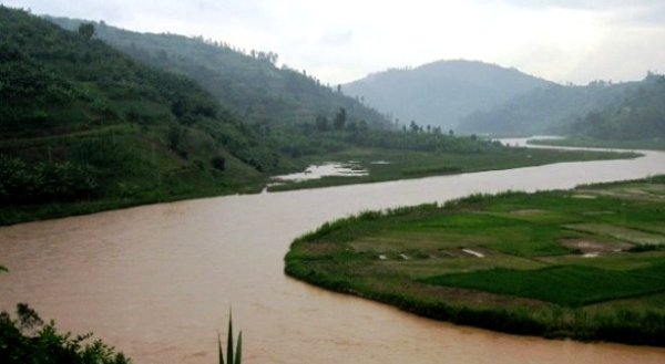
Within the confluence with Mukungwa River, Nyabarongo River alternates its course and flows eastward for about 12 kilometers approximately 7.5 miles, to southeast; it flows for about 200 kilometers. The longest course of this River forms a border between the northern and southern Province and between the Kigali capital and the southern Province, and finally between Kigali and the Eastern Province.
It then enters the Eastern Province and stops its course next to Burundi border. This River pours its water to Lake Rweru and Akagera River in a tiny though complicated Delta. Akagera River also outflows from Lake Rweru for about a kilometer from Nyabarongo delta. Nearly all the Nyabarongo delta branches pour water in Lake except one branch which pours directly to Akagera River. Akagera River flows into Lake Victoria and makes the mighty Nile.
Originally, Nyabarongo River starts from southwestern Rwanda covering the eastern side of Lake Kivu. Its sources rise in the mountain chain which covers the western 3rd of Rwanda and to the east of the Albertine rift. The major headwaters in Rwanda originating at heights of 2600 to 2750 meters include the River Mbirurume and Mwogo. Its longest streams which supply the Mwogo is Rukarara that rise in the Nyungwe Forest. Rukarara flows south and later to the east and then pours its water to River Mwogo which also flows north joining the Mbirurume River south of Bwakira. Rukarara source is a contender for the entire source of the mighty Nile which features as the most distant headwater.
Nyabarongo River flows northward along a chain of mountains in a deep valley which is parallel to Lake Kivu and approximately 1500 meters. From Muramba, flows to the southeast and on its left bank, the Nyabugogo River flows from Lake Muhazi. From Kigali, the River is mainly used for cooking, bathing and bathing. It receives sewage and waste products from industry and agriculture. Approximately, 35 kilometers downstream the Akanyaru River enters on its right bank to the southwest of Kigali. The joint river flows east and later southeast via a broad, swampy valley. Along the border area with Burundi, it drains the Rweru Lake. After, it flows east on the boundary between Burundi and Rwanda, between Tanzania and Rwanda, to an area where it merges the Ruvuvu River and from here onwards, it is referred as River Kagera which makes the major affluent of Lake Victoria that drains into the mighty Nile. This River then drains the east of the mountains and other areas of the Rwanda central plateau.
After being merged by the Akanyaru, the joint River winds east and later south via a complex of Lakes and wetlands in the flat valley which runs in the south-south east side, within a width of approximately 35 kilometers, it floods to make permanent swamps and Lakes. Lake Mugesera is located along the east bank of the River and the largest Rwanda Lake in the complex. Lake Birara and Sake are situated on the left bank of the River and the Lakes which are on the right bank, from north to south include Kidogo, Gashanga, Maravi, Kilimbi, Gaharwa, Kanzigiri and Rumira. Lake Rweru which is entirely situated in Burundi drains the northeast side to the River along a short swampy portion. Despite its proximity to the Equator, the climate is relatively temperate given its altitude. The wet season range from March to May and from September to December. Within the upper side, it extends to wetlands and the forest floods seasonally and there are plant species like ficus verruculosa, phoenix reclinata, Cyperus papyrus and Myrica kandtiana. The temperatures stand at 25 degrees Celsius. There are also varied fish species and aquatic birdlife (grey crowned crane, carruther’s Cisticola, papyrus yellow warbler, Sharpe’s pied babbler, white winged scrub warbler, northern brown throated papyrus gonolek, white collared olive back, papyrus canary, Malagasy pond heron) in this River including other water turtles, monitors, sitatunga, snakes, crocodiles, otters and others. This river covers an area of about 142.62 square kilometers.